I'm currently sat in a roadside cafe eating a large mixed grill, some salad and drinking coffee after a week of eating ham & cheese butties, thinking about all the ground I've covered in the last week on the Trans Euro Trail... mmm bikes do take you to some ace places!
Below are the notes from each day I've done so far with a bit of background at the start. (I'll apologise now as some of the pics might not match to the areas and I may well have repeated myself a few times)...

So the Romanian part of the TET is made up of a three possibilities,one that runs from Serbia to Hungary in a backwards C shape, (2296km), a second that runs from Serbia upto Ukraine, (1995km) and to be completed is the link between the Bulgaria section into either Serbia or Romania. So a few choices dependant upon time, personal preference etc etc. The route that finishes in Ukraine is shorter and not as convoluted as the Serbia/Hungary one, but this means you are missing out plenty of trails too. This may well change as the route settles down in the next few years.
For myself I wanted to start at the Ukraine border, so that any later trip could start there and then head north, I’m now gonna stick with this as a start point but go into Serbia or down into Bulgaria once I’ve ridden a fair bit of the Romanian section.
As my first week started near Carancebes riding with a few mates, I’ve ridden a fair bit around there, but not checked whether any of it was on the TET as yet. As I am waiting for Lucy, I thought I check out the parts around Sibiu & Brasov and the areas surrounding these towns. This northern section of the Romanian Carpathians, from Hungary or Ukraine heading down to Brasov, is lower in height than the Sibiu section and the weather is less extreme, so a little better for me to travel alone. All of the higest peaks in the Romanian Carpathians are here as is the famous Faragasan Pass. From the sections I’ve seen so far whilst driving the van around, none of it looks to technical so I’m happier to try to ride this alone, whereas the stuff I was doing around Carancebes I would not be happy to ride alone at all!
12 June 2017
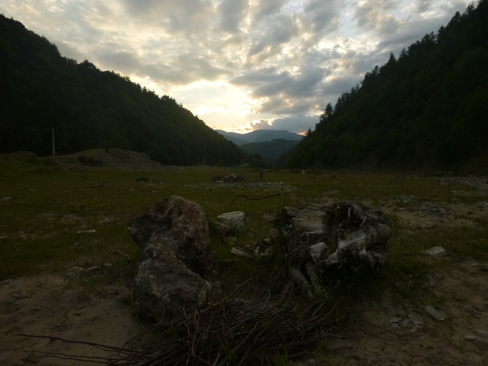
At the moment I’m sat in an unknown valley, with a dirt road running by the side of a river. There is evidence of some severe flooding, which I’d hazard a guess at comes in the spring with the snow melt from the 2000m+ mountains all around here.


For the last week I’ve ridden some tough trails in the mountains around Caransebes with a few mates from the UK. Absolutely beautiful mountains, rolling away into the distance, plenty of tough terrain, lots of rolling summits and ridges, steep ascents/descents, it’s got the lot! My UK mates have now all gone home and I’m killing time until Lucy turns up. I’m travelling in our van, mostly just looking at the TET trails so far that are accessible with such a big vehicle and every now and then I'll get the bike out for a ride out. For tonight, this campsite is a gem, you couldn’t find better, there is good flat ground, plenty of driftwood for a fire, easy access and almost no people, except for the odd car going by to somewhere to do something important no doubt!
I’ve just finished washing some bike kit in the river, I’ve opened the olives and the wine I bought earlier in the day and am now just sitting and reflecting on my first time in Romania.
It’s very much a land of contrasts, the people are lovely, generally chatty and smiley, certainly in the mountain areas anyway, the cities are the same as everywhere else, abrupt and in a hurry, so less tolerant as well. One one hand, I have driven past some flocks of sheep being driven up a lane, usually by guys, one younger, one older. Sometimes with a horse and cart, other times with a mule but just as often with nothing else except the big dogs. The guys are curious as they see my number plate and maybe do not recognise it, so they stare and wonder... I for my part, wave, try to say hi or nod in some way, but the lack of common language is an impediment. This morning I drove through a village, I stopped to take a photo of a beautiful church with mosaics painted all over the walls and was hailed by an old toothless and smiley guy who turned out to be the town drunk at a guess. Somehow I ended up giving him a lift up the village to his house, despite it not even being in the direction I wanted to go... still, he chatted, we both understood not a word of the other, but his gratitude at the lift was heart warming, even if the kiss on my hand was a little odd!


The contrast to this is the latest Audi’s & BMW’s whooshing by on the roads, the trucks, the good road surfaces, the whole westernised ‘shopping experience’ in Carrefour or the other larger chain stores which are to be found in any other European country, a land very much on the up it would appear.
I was part of a conversation with a local vet in Caransebes, he was saying that Romania was an affluent country, doing pretty well for itself, this seems true on one hand, then on the other, kids are begging coins off folk in the car parks, then taking the money to women sat in the shade smoking and talking like nothing was wrong with this child labour routine. Women were in the fields turning hay by hand, an age old tradition in every mountain region, yet next door is a very upmarket Pensiunaire, with a tarmac drive and large metal gates. All very contrasting, but it’s part of the charm of the place. It reminds me of France and Spain twenty or so years ago.


To be fair though, is this any different in any of the European countries or yet in any part of the world and hasn’t it always been this way? I had no expectations of Romania, as usual doing no research, just leaving myself like a blank page, hoping to find good impressions and memories written on them by the end of the trip
For myself I feel more at home in the mountains, more in tune and more relaxed. Even with a complete lack of language to talk to the locals, the mountains are my spiritual home, the wilder places of the world. I don’t understand or even like the ‘civilised places’ mankind has created in their cities and towns, they seem like another planet to me, decadent, dirty and completely out of touch with the natural order of the planet. I am totally aware that I am in a minority thinking like this but whenever I see the kind of contrasts I see here in Romania I wonder what the planet will be like in another 100 years or 500 years.


That said, I do appreciate some of the benefits of ‘modern world’, the internet, the van and most importantly my bike! All of which would not be available if we all lived back in a lifestyle of 200 years ago... hey ho, more contrasts mixed with a tinge of hypocrisy me thinks!
13th June
I left another idyllic little campsite this morning feeling really relaxed, the world was a better place and I felt more alert than I had in a long time, despite a lack of sleep through the night. As I drove out of the valley, stopping to take a few pictures along the way, I saw a few of the locals, the baker on his way to the next village in his battered old van, the farm hand, crossing himself and muttering a prayer as he walked past a roadside shrine to the field he would be working in today. In the little village of Greblesti, the kids were wandering down the road to their pick up for school, old ladies in black dresses were standing chatting, smartly dressed women were waiting for a bus at the junction of the main road, heading to somewhere to do something for the day. The world was turning as it does each day.
I turned onto the main road from Sibiu to Ramnicu Valcea following this just to see where it would take me, it was dirty, the river running alongside it was a dirty brown colour, the train on the other side of the river was a diesel train, coughing black smoke into the air as it chuntered by. People were in a hurry, lorries drove really close to me until I pulled in and let them past, then all queued up at the next set of roadworks with their hazard lights flashing.
Once at Ramnicu Valcea, I filled up with fuel again and bought a road map of Romania. I sat looking at it for a little while before I noticed the only truly bendy road for miles was to the north of this little city, so I decided to go investigate it, hoping it was the Transfagarasan Pass.


All the roads in Ramnicu seemed to go south or south east for some reason, so after a little bit of driving around, I got out the Garmin satnav and punched in the town of Curtea de Arges. A u turn, some meandering saw me on the road to Curtea de Arges, the entrance to the Transfagarasan Valley. I followed lots of bits of collapsed and winding road, (most buried in dense forest which also hid a lot of the ascent from the plain below), until eventually I popped out into another sprawling mass of Curtea.
All of the towns I have been through so far seem to be the same kind of style to them, lots of square buildings, (apparently a Russian influence), and a mix of houses, some grand, some dilapidated, all well lived in. This appeared to be a thriving place, plenty of people around the centre point which was a roundabout leading off in four directions. I turned left and started my ascent towards the Pass properly now.
A sign told me the Pass was 104kmn up the valley, the word ‘Nilhisy’ was on the sign too in big red letters, I guessed it meant either ‘open’ or ‘closed’ but as I didn’t know which I decided to try it anyway. There were loads of villages along the route, lots of Pensiunea’s advertising their accommodation available, a new sign stating this was a ‘Zona Touristica’ hence a little more affluence. I even saw a sign for an enduro bike guiding place...
At Lake Vidraru, I was a little bit surprised to see both the size and the colour of the place, it had the look of both a hydro electric scheme and maybe a water supply, it was huge, and the water colour was the beautiful blue that is normally only found in glacial water, but, here it must be snow melt, which also shows how much snow they must get!


For nearly two hours I wound my way up the valley, the road twisting all around the edge of the lake until it started the final climb, snow patches grew in size after each set of bends and just near the tunnel that passes through the mountain this road climbs, a solitary digger was clearing the last of the snow off the road surface leaving a huge wet puddle which all the motorcyclists were passing through gingerly just in case of hidden ice.
The tunnel itself is pretty poorly lit and you just couldn’t see if there was a rock or a big lump of snow in your lane, so it was a bit of pot luck and blind trust in the maintenance team. On the other side of the pass sits a dirty place of gravel, snow melt, rusty lifts, cafe’s and a lake, which was still semi frozen. People had parked and were up on the rocks taking pictures, so I got Roxy out of the van to do the same thing! We had a good walk around the place, took some photos of a group of German bikers in the lime green helmets and had a chat with a guy who clearly likes Labradors as he was really happy to see Roxy.


As I started the descent, I saw a guy on the side of the road, who turned out to be hitching to Sibiu, so I gave him a lift, he was an Israeli guy who had just taken two weeks holiday to Romainia to climb the highest peak here, Moldovenau, 2543m. We chatted about each others lives on the descent and stopped to take some pictures. I dropped him off and after failing to sort out a local sim card for one of the phones I had with me, I decided to find a place to stop for the night. The first place I pulled up into was too close to the road and between frustration at technology letting me down again and the road noise, I couldn’t stand it, so I moved on, leaving Roxy’s bowl in the car park! I found this out when I came to feed her as I had parked about two thirds of the way back up the hills of the Transfagarasan Pass. Back into the mountains for me and peace and quiet!

14th June 2017
After another lovely evening of watching the stars, the wind and the clouds, plus some good sleep, I woke up lazily at 8am. Roxy did not seem keen to move at all, probably stiff from chasing her tennis ball for 3 hours the night before! We breakfasted and cleaned up, then set off back down the valley. Once back on the main road I headed east towards Brasov, no real goal in mind but to look at some of the TET route again.
At Fagaras, I saw a beautiful church, with a huge golden dome, people were bustling around and there was a vibrant atmosphere, there was also a large moated castle, which looked medieval, so I need to do a little research on this one. Lovely place on the river, with swans in the castle moat and a picturesque footpath around the place.


At Brasov, I stopped for some shopping and to check the internet, Lucy was stuck in Lima, having missed her international flight due to internal flight delays, so was swanning around in a posh hotel for the night before heading to Brazil the next day. I tried to update the blog but no internet would let me so I gave up and headed out again.
I checked the route for the TET and saw it crossed a main road near a town called Nehoiu, about 50 km east of Brasov, so headed there, past another beautiful dammed lack, Lake Siriu. Once there I headed partway up the trail in the van to find another lovely little spot by a river and so parked up for the night.
I’m now itching to get on my bike, but very cautious of both leaving the van, Lucy’s bike inside and the dog, which if it gets too hot for her inside could be a problem, so I’m just going as far as I feel happy in the van, taking pictures wherever I can.
15th June 2017
With a bit of dithering about the ‘what if’s’ I decided to follow the TET route in the van today for a complete stage. The forest track was pretty good and was sign posted, leading me to believe it was the ‘normal’ road type in these parts. So I set off following the GPS. All in all the route was pretty good and the trail marked on the Open Street Map basemap was fairly accurate. At one point I was a little way off to the one side of the track and just thought this was a poor piece of route marking, but as it turned out I was on the wrong side of a river, having just come down a rather steep and damp piece of trail, which left me wondering whether, if I had to retrace my steps to find a missed turn, ‘’Would the van actually make that climb on these tyres?’’. Luck shone on me and there was a recent bridge added as a dam was being built to flood the valley, so although I got through OK, in the coming years, this bit of track will disappear under water I suspect.


Further along this trail, where I was supposed to turn right, there was a locked gate, which meant a detour, so I followed the signed route to the village of Compund Which turned out to be a lovely place with loads of pastures next to a beautiful mountain stream which would make some fab wild camping places. The village itself was sat at around 1100m, surrounded by dense forest and these pastures. There was a beautiful wooden statue of a wood cutter in a little park and the houses were lovely and fitted the setting exactly. Just like a movie set!

I found where the trail wound itself back up into the hills but decided I would forgo the stress of wondering if I would get stuck, especially after seeing a couple of sets of bear scat at various intervals along the mornings trail, so I opted for the easy route and descended the valley on what started as a tarmac lane, but soon became a windy dirt track down to the town at the bottom of the descent, some 25km later. There was fuel here I noted and a couple of supermarkets. Good to know!
After this I returned to Brasov to talk to Lucy, she is going to be delayed until the 22nd now, so after some deliberation and a look at the map and the GPS route, I decided to head to just south of the Ukraine border and start to ride sections of the TET from there. It was a six hour drive north, I made it for four, then had to crash in a carpark on the side of the road.
In between I had found a gem of a road for bike touring, the E60, what a beautiful road. Once you get out of the crappy northern section of Brasov, it opens out onto a fast, sweeping bendy wonder of a road, hairpins, then fast bends on lovely tarmac all the way to ??. This was dreary place from the southern end, but the centre was made up of a beautiful chateau perched on a hill above the town, a couple of very ornate and well kept churches and the river winding through the lot. This is the third amazing bike road I’ve found here and I’m sure there are more to come looking at the map... Just after this I had a puncture though, a bolt buried into a really good tyre. I changed to the spare which is the original from 2003 when the van was first put into service, so not so great and managed to secure a part worn from a Vulanister, who was a really helpful guy and it cost 150 lei or about £30. I still need a new one and a new spare + rim so will sort that out asap.
So I’m aiming for a road col just to the east of Bain Mare, I’ll park here, then get the bike out and head upto the Ukraine border, about 100km’s by the GPS, then come back to the van. The next day I’ll go south east and then return to the van. Each day now I plan to find a mid point, do the northern, then the southern section until I either run out of days or route. My deadline is the airport sometime on the evening of the 22nd to collect Lucy.
Right, I’ve had a beer, so sleep time I guess!
16th June 2017
I awoke a little groggy this morning, Roxy was eager for her breakfast, so we got sorted, then back on the road to the col above Baia Mare. Baia Mare is an odd place, it seems more busy than other towns, but dirty somehow. The people are a little less well dressed, the roads dirty, the streets have rubbish everywhere, almost like someone doesn’t care about it really.
The road upto the col was being relaid, so lots of roadworks. When it’s complete, it’ll be another biking gem, some seriously nice swithcbacks lead upto a cafe at the top. Then all the way down the other side too! There is a source a little ways down on the descent where an old man was using the water to wash his car, completely ignoring the lorries going by!

I followed the TET trail into the forest, parked the van up and got the bike out, then went for a play. The route winds through to a little ski village hidden in the trees. It’s not high, at only just over a 1000m but I suspect it gets a fair bit of snow this far north. I rode through to the tarmac road, which according to the map went on for a bit, so I decided to turn back to the van and the dog. On the way back I’d seen a couple of cut throughs that wound into the forest, so I took these. One ended up on another trail which rejoined mine, the other turned into a dead end, but was fun anyway. When I got back to the van, there seemed to be loads of people appeared, forestry lorries, 4x4’s, horses, so I packed up and headed to Sapanta, which is the proper northern start to the TET in Romania. It sits just inside the border, the river is the true dividing line I’d guess and it’s no mans land between the two lines. Who knows... Ukraine looked green and rolling in the distance, like Romania really! Sapanta is a roadside town, loads of Pensuineas, a couple of small mini markets and plenty of houses arranged along the road.
I checked out the TET from the end of the tarmac for a few miles and saw that it wound up into the tree line following a good surfaced piste past loads of farmsteads. Once I was happy where it went I turned back to the tarmac and drove around to the village of Leud, which is where the TET crosses on it’s way to Sacel. This was another roadside town, but this time it wound up into the hills to become a gravel road again. At the top I found a lovely little campsite by a river, cooked dinner and then got invited to a local farmers place. He spoke a little english, so that was a start!
17 June 2017
The cloud thickened up over night and some heavy rain fell, when I got up at 7am, there was a mist hanging in the trees, dense grey cloud threatened more rain. I dropped back down through Leud, turned right back onto the DN17 and followed this to the next junction with the TET. There was a fuel stop at the far end of Bogdan Voda, the nearest bit to the trail. Half way between Dragomiresti and Leud I’d guess.
The TET follows the DN17c which is a dirt road that winds through the forest eventually rejoining tarmac at a tiny hamlet called Fiad. It then follows the tarmac to the next village of Telciu, where at a Y junction in front of a bar and mini market it branches off heading back up into the hills, eventually becoming a dirt road again some 4 or 5 km later. This part passes through lots of rolling farmland and woodland rejoining the tarmac at the village of Sangeorz – Bal. (At this T junction, if you go right, there are two fuel garages about 1km down the road). The TET then follows tarmac on the DN17d for awhile before.
After this I headed up into the Calimani National Park It’s a random place, the approach road is fairly rubbish tarmac for about 25km, then you come to manned gate. The old guy on the gate is a lovely fella, very chatty and obliging. Once your on your way again, the road gets worse all the way to the ‘Cabane’, some 8 km past the gate. The random thing here is, along the way, several stands of trees are signed with their names, there is some effort to show a bit of management, but once you get the Cabane, you see your actually in a huge working quarry, (a little bit like the UK Peak District for those that know it!). The spoil heap is bigger than the quarry itself and that is saying something. The colours withing the layers of the quarry are beautiful and hidden in the trees above the ruined Cabane is another large impressive building which, today, only became visible once the cloud lifted out a bit. I turned around here as the route wasn’t suitable for the van any further and the rain was back with a vengeance. It has only stopped twice today!


I returned back to Varta, then decided to drive until it was dark, trying to complete this section of the GPX file. But dark came too soon, so I parked up after a lovely drive down the DN17. I haven’t quite figured out the numbering system for these roads but I guess I don’t need to really, just follow that magenta line on the GPS...
Hey ho, another day on the road. I’d prefer to be out on the bike doing this but I was being a total wuss today with all this rain... tomorrow is another day!
Below are the notes from each day I've done so far with a bit of background at the start. (I'll apologise now as some of the pics might not match to the areas and I may well have repeated myself a few times)...

So the Romanian part of the TET is made up of a three possibilities,one that runs from Serbia to Hungary in a backwards C shape, (2296km), a second that runs from Serbia upto Ukraine, (1995km) and to be completed is the link between the Bulgaria section into either Serbia or Romania. So a few choices dependant upon time, personal preference etc etc. The route that finishes in Ukraine is shorter and not as convoluted as the Serbia/Hungary one, but this means you are missing out plenty of trails too. This may well change as the route settles down in the next few years.
For myself I wanted to start at the Ukraine border, so that any later trip could start there and then head north, I’m now gonna stick with this as a start point but go into Serbia or down into Bulgaria once I’ve ridden a fair bit of the Romanian section.
As my first week started near Carancebes riding with a few mates, I’ve ridden a fair bit around there, but not checked whether any of it was on the TET as yet. As I am waiting for Lucy, I thought I check out the parts around Sibiu & Brasov and the areas surrounding these towns. This northern section of the Romanian Carpathians, from Hungary or Ukraine heading down to Brasov, is lower in height than the Sibiu section and the weather is less extreme, so a little better for me to travel alone. All of the higest peaks in the Romanian Carpathians are here as is the famous Faragasan Pass. From the sections I’ve seen so far whilst driving the van around, none of it looks to technical so I’m happier to try to ride this alone, whereas the stuff I was doing around Carancebes I would not be happy to ride alone at all!
12 June 2017
At the moment I’m sat in an unknown valley, with a dirt road running by the side of a river. There is evidence of some severe flooding, which I’d hazard a guess at comes in the spring with the snow melt from the 2000m+ mountains all around here.


For the last week I’ve ridden some tough trails in the mountains around Caransebes with a few mates from the UK. Absolutely beautiful mountains, rolling away into the distance, plenty of tough terrain, lots of rolling summits and ridges, steep ascents/descents, it’s got the lot! My UK mates have now all gone home and I’m killing time until Lucy turns up. I’m travelling in our van, mostly just looking at the TET trails so far that are accessible with such a big vehicle and every now and then I'll get the bike out for a ride out. For tonight, this campsite is a gem, you couldn’t find better, there is good flat ground, plenty of driftwood for a fire, easy access and almost no people, except for the odd car going by to somewhere to do something important no doubt!
I’ve just finished washing some bike kit in the river, I’ve opened the olives and the wine I bought earlier in the day and am now just sitting and reflecting on my first time in Romania.
It’s very much a land of contrasts, the people are lovely, generally chatty and smiley, certainly in the mountain areas anyway, the cities are the same as everywhere else, abrupt and in a hurry, so less tolerant as well. One one hand, I have driven past some flocks of sheep being driven up a lane, usually by guys, one younger, one older. Sometimes with a horse and cart, other times with a mule but just as often with nothing else except the big dogs. The guys are curious as they see my number plate and maybe do not recognise it, so they stare and wonder... I for my part, wave, try to say hi or nod in some way, but the lack of common language is an impediment. This morning I drove through a village, I stopped to take a photo of a beautiful church with mosaics painted all over the walls and was hailed by an old toothless and smiley guy who turned out to be the town drunk at a guess. Somehow I ended up giving him a lift up the village to his house, despite it not even being in the direction I wanted to go... still, he chatted, we both understood not a word of the other, but his gratitude at the lift was heart warming, even if the kiss on my hand was a little odd!


The contrast to this is the latest Audi’s & BMW’s whooshing by on the roads, the trucks, the good road surfaces, the whole westernised ‘shopping experience’ in Carrefour or the other larger chain stores which are to be found in any other European country, a land very much on the up it would appear.
I was part of a conversation with a local vet in Caransebes, he was saying that Romania was an affluent country, doing pretty well for itself, this seems true on one hand, then on the other, kids are begging coins off folk in the car parks, then taking the money to women sat in the shade smoking and talking like nothing was wrong with this child labour routine. Women were in the fields turning hay by hand, an age old tradition in every mountain region, yet next door is a very upmarket Pensiunaire, with a tarmac drive and large metal gates. All very contrasting, but it’s part of the charm of the place. It reminds me of France and Spain twenty or so years ago.


To be fair though, is this any different in any of the European countries or yet in any part of the world and hasn’t it always been this way? I had no expectations of Romania, as usual doing no research, just leaving myself like a blank page, hoping to find good impressions and memories written on them by the end of the trip
For myself I feel more at home in the mountains, more in tune and more relaxed. Even with a complete lack of language to talk to the locals, the mountains are my spiritual home, the wilder places of the world. I don’t understand or even like the ‘civilised places’ mankind has created in their cities and towns, they seem like another planet to me, decadent, dirty and completely out of touch with the natural order of the planet. I am totally aware that I am in a minority thinking like this but whenever I see the kind of contrasts I see here in Romania I wonder what the planet will be like in another 100 years or 500 years.

That said, I do appreciate some of the benefits of ‘modern world’, the internet, the van and most importantly my bike! All of which would not be available if we all lived back in a lifestyle of 200 years ago... hey ho, more contrasts mixed with a tinge of hypocrisy me thinks!
13th June
I left another idyllic little campsite this morning feeling really relaxed, the world was a better place and I felt more alert than I had in a long time, despite a lack of sleep through the night. As I drove out of the valley, stopping to take a few pictures along the way, I saw a few of the locals, the baker on his way to the next village in his battered old van, the farm hand, crossing himself and muttering a prayer as he walked past a roadside shrine to the field he would be working in today. In the little village of Greblesti, the kids were wandering down the road to their pick up for school, old ladies in black dresses were standing chatting, smartly dressed women were waiting for a bus at the junction of the main road, heading to somewhere to do something for the day. The world was turning as it does each day.
I turned onto the main road from Sibiu to Ramnicu Valcea following this just to see where it would take me, it was dirty, the river running alongside it was a dirty brown colour, the train on the other side of the river was a diesel train, coughing black smoke into the air as it chuntered by. People were in a hurry, lorries drove really close to me until I pulled in and let them past, then all queued up at the next set of roadworks with their hazard lights flashing.
Once at Ramnicu Valcea, I filled up with fuel again and bought a road map of Romania. I sat looking at it for a little while before I noticed the only truly bendy road for miles was to the north of this little city, so I decided to go investigate it, hoping it was the Transfagarasan Pass.


All the roads in Ramnicu seemed to go south or south east for some reason, so after a little bit of driving around, I got out the Garmin satnav and punched in the town of Curtea de Arges. A u turn, some meandering saw me on the road to Curtea de Arges, the entrance to the Transfagarasan Valley. I followed lots of bits of collapsed and winding road, (most buried in dense forest which also hid a lot of the ascent from the plain below), until eventually I popped out into another sprawling mass of Curtea.
All of the towns I have been through so far seem to be the same kind of style to them, lots of square buildings, (apparently a Russian influence), and a mix of houses, some grand, some dilapidated, all well lived in. This appeared to be a thriving place, plenty of people around the centre point which was a roundabout leading off in four directions. I turned left and started my ascent towards the Pass properly now.
A sign told me the Pass was 104kmn up the valley, the word ‘Nilhisy’ was on the sign too in big red letters, I guessed it meant either ‘open’ or ‘closed’ but as I didn’t know which I decided to try it anyway. There were loads of villages along the route, lots of Pensiunea’s advertising their accommodation available, a new sign stating this was a ‘Zona Touristica’ hence a little more affluence. I even saw a sign for an enduro bike guiding place...
At Lake Vidraru, I was a little bit surprised to see both the size and the colour of the place, it had the look of both a hydro electric scheme and maybe a water supply, it was huge, and the water colour was the beautiful blue that is normally only found in glacial water, but, here it must be snow melt, which also shows how much snow they must get!


For nearly two hours I wound my way up the valley, the road twisting all around the edge of the lake until it started the final climb, snow patches grew in size after each set of bends and just near the tunnel that passes through the mountain this road climbs, a solitary digger was clearing the last of the snow off the road surface leaving a huge wet puddle which all the motorcyclists were passing through gingerly just in case of hidden ice.
The tunnel itself is pretty poorly lit and you just couldn’t see if there was a rock or a big lump of snow in your lane, so it was a bit of pot luck and blind trust in the maintenance team. On the other side of the pass sits a dirty place of gravel, snow melt, rusty lifts, cafe’s and a lake, which was still semi frozen. People had parked and were up on the rocks taking pictures, so I got Roxy out of the van to do the same thing! We had a good walk around the place, took some photos of a group of German bikers in the lime green helmets and had a chat with a guy who clearly likes Labradors as he was really happy to see Roxy.


As I started the descent, I saw a guy on the side of the road, who turned out to be hitching to Sibiu, so I gave him a lift, he was an Israeli guy who had just taken two weeks holiday to Romainia to climb the highest peak here, Moldovenau, 2543m. We chatted about each others lives on the descent and stopped to take some pictures. I dropped him off and after failing to sort out a local sim card for one of the phones I had with me, I decided to find a place to stop for the night. The first place I pulled up into was too close to the road and between frustration at technology letting me down again and the road noise, I couldn’t stand it, so I moved on, leaving Roxy’s bowl in the car park! I found this out when I came to feed her as I had parked about two thirds of the way back up the hills of the Transfagarasan Pass. Back into the mountains for me and peace and quiet!

14th June 2017
After another lovely evening of watching the stars, the wind and the clouds, plus some good sleep, I woke up lazily at 8am. Roxy did not seem keen to move at all, probably stiff from chasing her tennis ball for 3 hours the night before! We breakfasted and cleaned up, then set off back down the valley. Once back on the main road I headed east towards Brasov, no real goal in mind but to look at some of the TET route again.
At Fagaras, I saw a beautiful church, with a huge golden dome, people were bustling around and there was a vibrant atmosphere, there was also a large moated castle, which looked medieval, so I need to do a little research on this one. Lovely place on the river, with swans in the castle moat and a picturesque footpath around the place.


At Brasov, I stopped for some shopping and to check the internet, Lucy was stuck in Lima, having missed her international flight due to internal flight delays, so was swanning around in a posh hotel for the night before heading to Brazil the next day. I tried to update the blog but no internet would let me so I gave up and headed out again.
I checked the route for the TET and saw it crossed a main road near a town called Nehoiu, about 50 km east of Brasov, so headed there, past another beautiful dammed lack, Lake Siriu. Once there I headed partway up the trail in the van to find another lovely little spot by a river and so parked up for the night.
I’m now itching to get on my bike, but very cautious of both leaving the van, Lucy’s bike inside and the dog, which if it gets too hot for her inside could be a problem, so I’m just going as far as I feel happy in the van, taking pictures wherever I can.
15th June 2017
With a bit of dithering about the ‘what if’s’ I decided to follow the TET route in the van today for a complete stage. The forest track was pretty good and was sign posted, leading me to believe it was the ‘normal’ road type in these parts. So I set off following the GPS. All in all the route was pretty good and the trail marked on the Open Street Map basemap was fairly accurate. At one point I was a little way off to the one side of the track and just thought this was a poor piece of route marking, but as it turned out I was on the wrong side of a river, having just come down a rather steep and damp piece of trail, which left me wondering whether, if I had to retrace my steps to find a missed turn, ‘’Would the van actually make that climb on these tyres?’’. Luck shone on me and there was a recent bridge added as a dam was being built to flood the valley, so although I got through OK, in the coming years, this bit of track will disappear under water I suspect.


Further along this trail, where I was supposed to turn right, there was a locked gate, which meant a detour, so I followed the signed route to the village of Compund Which turned out to be a lovely place with loads of pastures next to a beautiful mountain stream which would make some fab wild camping places. The village itself was sat at around 1100m, surrounded by dense forest and these pastures. There was a beautiful wooden statue of a wood cutter in a little park and the houses were lovely and fitted the setting exactly. Just like a movie set!

I found where the trail wound itself back up into the hills but decided I would forgo the stress of wondering if I would get stuck, especially after seeing a couple of sets of bear scat at various intervals along the mornings trail, so I opted for the easy route and descended the valley on what started as a tarmac lane, but soon became a windy dirt track down to the town at the bottom of the descent, some 25km later. There was fuel here I noted and a couple of supermarkets. Good to know!
After this I returned to Brasov to talk to Lucy, she is going to be delayed until the 22nd now, so after some deliberation and a look at the map and the GPS route, I decided to head to just south of the Ukraine border and start to ride sections of the TET from there. It was a six hour drive north, I made it for four, then had to crash in a carpark on the side of the road.
In between I had found a gem of a road for bike touring, the E60, what a beautiful road. Once you get out of the crappy northern section of Brasov, it opens out onto a fast, sweeping bendy wonder of a road, hairpins, then fast bends on lovely tarmac all the way to ??. This was dreary place from the southern end, but the centre was made up of a beautiful chateau perched on a hill above the town, a couple of very ornate and well kept churches and the river winding through the lot. This is the third amazing bike road I’ve found here and I’m sure there are more to come looking at the map... Just after this I had a puncture though, a bolt buried into a really good tyre. I changed to the spare which is the original from 2003 when the van was first put into service, so not so great and managed to secure a part worn from a Vulanister, who was a really helpful guy and it cost 150 lei or about £30. I still need a new one and a new spare + rim so will sort that out asap.
So I’m aiming for a road col just to the east of Bain Mare, I’ll park here, then get the bike out and head upto the Ukraine border, about 100km’s by the GPS, then come back to the van. The next day I’ll go south east and then return to the van. Each day now I plan to find a mid point, do the northern, then the southern section until I either run out of days or route. My deadline is the airport sometime on the evening of the 22nd to collect Lucy.
Right, I’ve had a beer, so sleep time I guess!
16th June 2017
I awoke a little groggy this morning, Roxy was eager for her breakfast, so we got sorted, then back on the road to the col above Baia Mare. Baia Mare is an odd place, it seems more busy than other towns, but dirty somehow. The people are a little less well dressed, the roads dirty, the streets have rubbish everywhere, almost like someone doesn’t care about it really.
The road upto the col was being relaid, so lots of roadworks. When it’s complete, it’ll be another biking gem, some seriously nice swithcbacks lead upto a cafe at the top. Then all the way down the other side too! There is a source a little ways down on the descent where an old man was using the water to wash his car, completely ignoring the lorries going by!

I followed the TET trail into the forest, parked the van up and got the bike out, then went for a play. The route winds through to a little ski village hidden in the trees. It’s not high, at only just over a 1000m but I suspect it gets a fair bit of snow this far north. I rode through to the tarmac road, which according to the map went on for a bit, so I decided to turn back to the van and the dog. On the way back I’d seen a couple of cut throughs that wound into the forest, so I took these. One ended up on another trail which rejoined mine, the other turned into a dead end, but was fun anyway. When I got back to the van, there seemed to be loads of people appeared, forestry lorries, 4x4’s, horses, so I packed up and headed to Sapanta, which is the proper northern start to the TET in Romania. It sits just inside the border, the river is the true dividing line I’d guess and it’s no mans land between the two lines. Who knows... Ukraine looked green and rolling in the distance, like Romania really! Sapanta is a roadside town, loads of Pensuineas, a couple of small mini markets and plenty of houses arranged along the road.
I checked out the TET from the end of the tarmac for a few miles and saw that it wound up into the tree line following a good surfaced piste past loads of farmsteads. Once I was happy where it went I turned back to the tarmac and drove around to the village of Leud, which is where the TET crosses on it’s way to Sacel. This was another roadside town, but this time it wound up into the hills to become a gravel road again. At the top I found a lovely little campsite by a river, cooked dinner and then got invited to a local farmers place. He spoke a little english, so that was a start!
17 June 2017
The cloud thickened up over night and some heavy rain fell, when I got up at 7am, there was a mist hanging in the trees, dense grey cloud threatened more rain. I dropped back down through Leud, turned right back onto the DN17 and followed this to the next junction with the TET. There was a fuel stop at the far end of Bogdan Voda, the nearest bit to the trail. Half way between Dragomiresti and Leud I’d guess.
The TET follows the DN17c which is a dirt road that winds through the forest eventually rejoining tarmac at a tiny hamlet called Fiad. It then follows the tarmac to the next village of Telciu, where at a Y junction in front of a bar and mini market it branches off heading back up into the hills, eventually becoming a dirt road again some 4 or 5 km later. This part passes through lots of rolling farmland and woodland rejoining the tarmac at the village of Sangeorz – Bal. (At this T junction, if you go right, there are two fuel garages about 1km down the road). The TET then follows tarmac on the DN17d for awhile before.
After this I headed up into the Calimani National Park It’s a random place, the approach road is fairly rubbish tarmac for about 25km, then you come to manned gate. The old guy on the gate is a lovely fella, very chatty and obliging. Once your on your way again, the road gets worse all the way to the ‘Cabane’, some 8 km past the gate. The random thing here is, along the way, several stands of trees are signed with their names, there is some effort to show a bit of management, but once you get the Cabane, you see your actually in a huge working quarry, (a little bit like the UK Peak District for those that know it!). The spoil heap is bigger than the quarry itself and that is saying something. The colours withing the layers of the quarry are beautiful and hidden in the trees above the ruined Cabane is another large impressive building which, today, only became visible once the cloud lifted out a bit. I turned around here as the route wasn’t suitable for the van any further and the rain was back with a vengeance. It has only stopped twice today!


I returned back to Varta, then decided to drive until it was dark, trying to complete this section of the GPX file. But dark came too soon, so I parked up after a lovely drive down the DN17. I haven’t quite figured out the numbering system for these roads but I guess I don’t need to really, just follow that magenta line on the GPS...
Hey ho, another day on the road. I’d prefer to be out on the bike doing this but I was being a total wuss today with all this rain... tomorrow is another day!